How Many Times Has New York Trembled? Uncover NYC's Quake Past!
New York City, a global metropolis renowned for its towering skyscrapers and vibrant energy, often feels invincible. Yet, beneath its bustling surface, the underlying bedrock experiences subtle tremors, prompting many to ask: cuantas veces a temblado en New York? Understanding the seismic activity that shapes this region requires delving into its unique geological characteristics, particularly the presence of ancient faults. Experts utilize sophisticated seismographs and advanced seismology to monitor these events, providing crucial data for urban infrastructure planning and public safety. Organizations like the United States Geological Survey (USGS) consistently track these occurrences, offering valuable insights into the city's earthquake vulnerability and historical patterns.
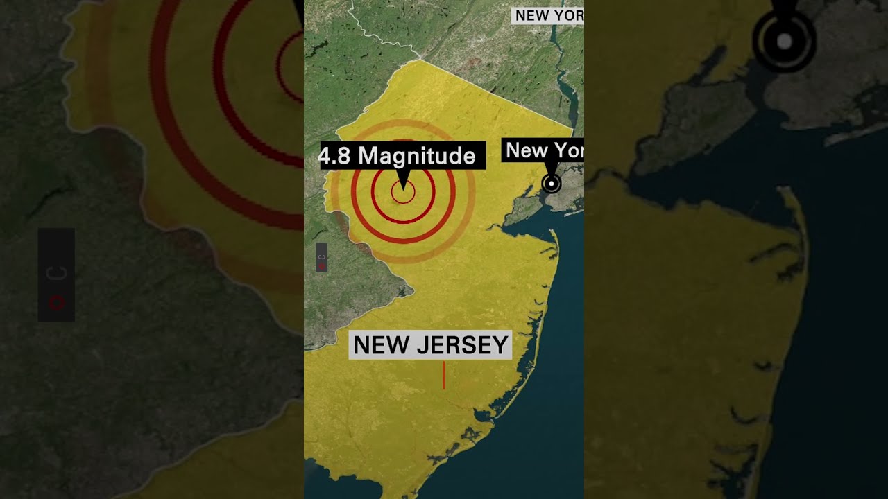
Image taken from the YouTube channel Univision Nueva York , from the video titled Sismo en Nueva York: Temblor de 4.8 gratos sorprende a clientes de negocios en Nueva York .
For many, the very notion of New York City and earthquakes existing in the same sentence seems almost contradictory. The iconic skyline, built on what appears to be unshakeable bedrock, has long fostered a widespread perception of the city's absolute seismic stability. This common belief, however, overlooks a surprising and often-forgotten geological reality.
When the Concrete Jungle Trembled
That perception of invulnerability was abruptly challenged on April 5, 2024, at approximately 10:23 AM EDT. A magnitude 4.8 earthquake, centered near Whitehouse Station, New Jersey, sent unmistakable tremors through the entire New York City metropolitan area. This event, strongly felt from Brooklyn to the Bronx, rattled buildings, sparked widespread social media discussion, and prompted immediate public awareness that earthquakes are not just a West Coast phenomenon.
The New Jersey earthquake served as a stark reminder that even a bustling metropolis like NYC is not immune to geological forces. It shattered the comfortable illusion of perpetual stillness, drawing attention to a subject few New Yorkers had previously considered.
Unearthing NYC's Seismic Past
This recent seismic jolt has brought the topic of earthquakes directly into the public consciousness, setting the stage for a critical exploration. Beyond the recent tremors, New York City possesses an often-overlooked and surprisingly active seismic history. This article aims to delve deep into that past, answering a fundamental question that has emerged in the wake of recent events: ¿cuántas veces ha temblado en Nueva York? (how many times has it shaken in New York?). By unearthing the city's seismic legacy, we will reveal a narrative that challenges popular belief and provides a more comprehensive understanding of NYC's true geological landscape.
Having established the surprising reality that New York City is indeed susceptible to seismic activity, particularly in light of recent tremors, it's crucial to address a deeply ingrained misconception. Many New Yorkers, and indeed many across the globe, operate under the assumption that the Big Apple exists in a serene, seismically inert bubble. This belief, however, is far from the truth.
Dispelling Myths: NYC is Not Immune to Earthquakes
The common perception that New York City is seismically inactive is a pervasive myth, largely born from the relative infrequency of large-magnitude events compared to regions like California or Japan. While major, destructive earthquakes are rare, the area experiences ongoing seismic activity, often in the form of smaller, imperceptible tremors, or noticeable but non-damaging quakes like the one in April 2024. This activity is a consistent, albeit low-level, feature of the Eastern United States’ geological landscape, directly contradicting the notion of immunity.
Understanding East Coast Earthquakes
Unlike the highly active plate boundaries that define the "Ring of Fire" in the Pacific, earthquakes in the Eastern United States are primarily intraplate earthquakes. This means they occur within the interior of the North American tectonic plate, far from its edges. The geological mechanisms at play here are distinct and often less intuitive:
- Ancient Fault Lines: The East Coast is crisscrossed by numerous ancient fault lines, remnants of bygone geological eras, such as the breakup of the supercontinent Pangaea millions of years ago. While these faults are no longer active in the sense of plate movement, they remain zones of weakness within the crust.
- Transmitted Stress: The immense stresses generated by the slow, continuous spreading of the Mid-Atlantic Ridge exert pressure on the entire North American plate. This stress builds up and is occasionally released along these pre-existing zones of weakness, causing the crust to fracture and shift, resulting in an earthquake.
- Rigid Crust: The older, colder, and more rigid crust of the Eastern U.S. allows seismic waves to travel more efficiently over greater distances compared to the warmer, more fractured crust found in active plate boundary regions. This is why even moderate earthquakes on the East Coast can be felt across a very wide area.
Defining Seismic Activity in the Region
When we speak of seismic activity in the context of the New York City region, we are referring to these recurring tremors and earthquakes, regardless of their magnitude. While the region does not experience the daily jolts common in California, it is by no means quiet. The U.S. Geological Survey (USGS) and local geological observatories regularly record small quakes throughout the Northeast. For instance, the Ramapo Fault Zone, stretching through parts of New Jersey, New York, and Pennsylvania, is a notable ancient structure that has been associated with historical seismic events, though many quakes in the region occur on smaller, unmapped faults. This continuous, though often subtle, geological movement underscores that New York City is not just not immune, but is, in fact, an active participant in the ongoing seismic narrative of the Eastern United States.
Building on our understanding of why seismic events occur in the Eastern United States, it's crucial to ground this knowledge in the tangible past. While the concept of NYC's vulnerability might seem theoretical, historical records provide compelling evidence that New York City has indeed experienced significant tremors, shaping its unacknowledged seismic narrative.
A Deep Dive into NYC's Quake Past: Significant Tremors
New York City's geological history is punctuated by various seismic events, some of which were substantial enough to be widely felt and recorded. By examining these historical tremors, we gain concrete insight into the city's inherent seismic character, moving beyond common misconceptions to embrace a factual understanding of its past.
The 1884 New York City Earthquake: A Landmark Event
Among the most notable seismic events in the region's recorded history is the earthquake that struck on August 10, 1884. This tremor serves as a powerful reminder of New York City's seismic susceptibility.
Geologists and seismologists have estimated its magnitude to be around 5.0 to 5.5. While not a devastating "great" earthquake, its impact was widely felt across an expansive area, from Maine to Virginia and west into Ohio.
In New York City itself, the 1884 earthquake caused considerable alarm and minor structural damage. Reports from the time detail:
- Widespread cracked plaster in buildings.
- Falling chimneys in some areas.
- Windows rattling violently, and furniture shaking.
- A significant sense of panic among residents, with many rushing into the streets.
The event generated widespread newspaper coverage, illustrating the profound impact it had on the public consciousness. Its significance lies in its widespread perceptibility and relatively strong intensity for the region, making it a pivotal event in the recorded seismic history of the New York metropolitan area. It emphatically demonstrated that even major East Coast population centers are not immune to ground shaking.
Other Notable Historical Tremors Affecting NYC
Beyond the prominent 1884 event, New York City has felt the effects of numerous other earthquakes throughout its history, albeit often smaller in magnitude or less centrally located. These incidents further underscore the city's consistent, if sometimes subtle, seismic activity.
Some of these historical occurrences include:
- A notable earthquake in 1737, estimated to be around magnitude 5.0, which was felt throughout New York City and parts of New England.
- The 1783 tremor, also estimated around magnitude 5.0, centered near New York City and widely felt.
- Smaller, yet still perceptible, events like the 1840 earthquake (estimated M 4.5), which caused buildings to shake, and a 4.1 magnitude tremor in 1895 that was also felt in the city.
These events, while perhaps less dramatic than the 1884 quake, collectively paint a picture of a region that has always experienced, and continues to experience, seismic shifts. They are crucial pieces of the puzzle when understanding New York City's long-term relationship with the ground beneath it.
While historical tremors like the 1884 event certainly highlight New York City's vulnerability to seismic activity, understanding why these events occur requires delving beneath the surface. The true story of the region's earthquake potential lies within the complex geological structures that crisscross the bedrock, particularly a few key fault lines.
The Geology Beneath: Fault Lines and Regional Activity
Understanding the underlying geological structures contributing to seismic activity in and around New York City is crucial for comprehending the region's earthquake potential. The Eastern United States, despite not being on a major plate boundary, experiences regular intraplate seismic activity due to ancient fault zones that lie within the North American tectonic plate.
The Ramapo Fault: A Key Player
One of the most significant regional geological structures is the Ramapo Fault. This extensive fault system stretches approximately 70 miles (110 kilometers), extending from southeastern New York through northern New Jersey and into Pennsylvania. It is considered one of the longest and most active faults in the Eastern U.S.
As a significant regional fault line, the Ramapo Fault represents a zone of weakness in the Earth's crust. Movement along such fault lines generates earthquakes when stress, accumulated over long periods from the slow, inexorable movements of tectonic plates, suddenly releases. While the Ramapo Fault is an ancient structure, formed millions of years ago during the assembly of the supercontinent Pangea and the formation of the Appalachian Mountains, it remains active. Even minor shifts along this or related fault segments can cause noticeable tremors in the densely populated Tri-State area.
Broader Regional Seismic Activity
While the Ramapo Fault receives considerable attention due to its size and proximity to major population centers, it is not the only contributing factor to the region's seismicity. Numerous other, often smaller or less-defined fault lines, exist throughout New Jersey and the broader Mid-Atlantic region. Many of these faults are buried deep beneath glacial deposits or urban development, making them challenging to map precisely.
The seismic activity in the Eastern U.S. is generally more diffuse compared to plate boundary regions like California. Instead of distinct, large fault zones, seismic energy can be released along a network of interconnected and sometimes unnamed faults. This complex geological fabric contributes to the ongoing, albeit often low-magnitude, earthquake activity experienced across the region, reminding us of the dynamic nature of the Earth's crust beneath our feet.
Building on our understanding of the persistent geological forces that shape the Northeast's seismic landscape, a recent event brought the abstract concept of fault line movement into vivid, immediate focus for millions.
The April 2024 New Jersey Earthquake: A Recent Reminder
The April 2024 New Jersey earthquake served as a potent and unforgettable reminder of the East Coast's seismic vulnerability and New York City's interconnectedness with regional geological activity. This event, felt widely across a densely populated corridor, underscored that while major earthquakes are less frequent here than in other parts of the world, the potential for them remains very real.
The Main Event: Origin and Magnitude
On Friday, April 5, 2024, at 10:23 AM EDT, a magnitude 4.8 earthquake struck near Whitehouse Station, Hunterdon County, New Jersey. This location, approximately 45 miles west of New York City, was the epicenter of a seismic event that reverberated through the tri-state area and beyond. The earthquake's relatively shallow depth, estimated at around 4.7 kilometers (2.9 miles), contributed to its widespread perceptibility. While a 4.8 magnitude event is considered moderate, its occurrence in a region unaccustomed to such tremors made it particularly jarring.
Shaking New York City
The tremors from the New Jersey earthquake were felt profoundly across all five boroughs of New York City. Residents reported buildings swaying, objects rattling, and a distinct shaking sensation that prompted widespread confusion and alarm. Many experienced a moment of disbelief, unaccustomed to the ground moving beneath them. Despite the unsettling experience and widespread reports of shaking, initial assessments revealed no major structural damage or significant casualties within NYC, a testament to the city's building codes designed to withstand various stresses, though not primarily for high-magnitude seismic events.
Aftershocks and Lingering Awareness
Following the main shock, a series of aftershocks occurred, further underscoring the ongoing seismic adjustments in the Earth's crust. While most were small and imperceptible to the general public, a notable aftershock occurred on May 17, 2024, registering a magnitude 4.0 in the same general area of central New Jersey. These subsequent events, especially the more significant ones, kept the earthquake in the public consciousness, reminding residents that the Earth's movements are not always a one-time occurrence. This prolonged activity contributed to a heightened sense of awareness regarding regional seismic potential.
A Wake-Up Call for Regional Preparedness
The April 2024 earthquake vividly highlighted New York City's intrinsic connection to regional seismic activity. Though the epicenter was in New Jersey, the impact on NYC was immediate and widely felt. This event served as a crucial reminder that geological fault lines, some of which we explored in the previous section, do not respect state boundaries. The widespread tremors demonstrated that any significant seismic event in the surrounding tristate area—be it along the Ramapo Fault or other lesser-known fault structures—can directly affect the infrastructure and daily lives of millions in New York City, emphasizing the need for robust regional preparedness and public education.
While the April 2024 New Jersey earthquake served as a potent, immediate reminder of the East Coast's seismic activity, it’s crucial to understand that this event is not an anomaly but rather a component of a much broader regional context. To truly grasp New York City's seismic profile, we must situate it within the larger historical and geological framework of East Coast seismic events.
Broader Context: East Coast Seismic Events
New York City, despite not being located on a major plate boundary like the West Coast, is nonetheless part of an active seismic region. The East Coast experiences what is known as intraplate seismicity – earthquakes occurring within the stable interior of the North American tectonic plate, rather than at its edges. These events, while less frequent and generally smaller in magnitude than those in California, can still have significant impacts due to the unique geological characteristics of the region.
The 2011 Virginia Earthquake: A Widespread Impact
A prime example of how distant seismic events can profoundly affect New York City and the wider East Coast is the Magnitude 5.8 earthquake that struck central Virginia on August 23, 2011. Originating near Mineral, Virginia, approximately 300 miles southwest of New York City, this earthquake was the largest to strike Virginia since 1897 and was felt across an extraordinarily wide area.
Tremors from the 2011 Virginia earthquake were experienced by an estimated one-third of the U.S. population, from Georgia to Canada, making it one of the most widely felt earthquakes in U.S. history. In New York City, the shaking was significant enough to prompt evacuations of high-rise buildings, including City Hall and federal courthouses, and caused temporary disruptions to subway service. While structural damage in NYC was minimal, the event highlighted the vulnerability of urban infrastructure to distant seismic activity.
Understanding Distant Earthquakes' Impact on New York City
The widespread propagation of seismic waves from the 2011 Virginia earthquake, and similarly from the 2024 New Jersey event, can be attributed to the fundamental differences in geological structure between the East and West Coasts. The East Coast's crust is older, colder, and more rigid compared to the fractured and warmer crust of the West Coast.
This denser, more intact geology acts as an efficient conduit for seismic energy. When an earthquake occurs in this environment, the seismic waves attenuate (lose energy) much more slowly. As a result, an earthquake of a given magnitude on the East Coast can be felt over a significantly larger geographical area compared to an earthquake of the same magnitude on the West Coast. This explains why a moderate quake in Virginia or New Jersey can send perceptible tremors through skyscrapers in New York City, reminding residents that seismic activity, even when originating far away, is a tangible part of the city's broader environmental context.
While understanding the broader East Coast seismic context helps frame New York City's vulnerability, a deeper dive into the city's seismic story requires looking at the specialized institutions and dedicated experts who are actively monitoring and researching its unique geological landscape. This vital work is crucial for understanding the local fault lines and improving our ability to predict future tremors.
Monitoring and Research: The Experts Tracking NYC's Tremors
The ongoing safety and preparedness of New York City depend heavily on the diligent work of scientific institutions and experts. These organizations are at the forefront of understanding and monitoring seismic activity in and around the metropolitan area, providing critical data and insights.
The United States Geological Survey (USGS)
A cornerstone of national seismic monitoring, the United States Geological Survey (USGS) plays a crucial role in tracking and reporting on earthquakes and seismic activity across the nation, including the New York City region. The USGS operates and coordinates a vast network of seismic sensors, feeding real-time data into a comprehensive system.
Through its Earthquake Hazards Program, the USGS collects information, conducts research, and provides immediate notifications for seismic events. This data is essential for emergency responders, engineers, and the public, offering a clear picture of an earthquake's location, depth, and magnitude. For areas like NYC, which experience less frequent but notable tremors, the USGS's continuous monitoring provides foundational data for local hazard assessments.
Insights from Lamont-Doherty Earth Observatory
Closer to home, the Lamont-Doherty Earth Observatory (LDEO), a research unit of Columbia University, is a world-renowned institution with a specific focus on the geology and seismicity of the New York City metropolitan area. Located just north of the city in Palisades, New York, LDEO scientists have been instrumental in studying the region's complex network of ancient fault lines.
Researchers at Lamont-Doherty use a variety of techniques, including deploying temporary and permanent seismometers, to map subsurface structures and understand the characteristics of local seismic activity. Their work contributes significantly to our knowledge of how stress accumulates along these fault lines and how this might relate to future earthquake potential. Insights from LDEO are vital for local authorities in developing seismic hazard maps and emergency preparedness plans tailored to the unique geological setting of New York.
Analyzing Magnitude Data
A critical aspect of understanding any earthquake, whether large or small, is its magnitude. Experts rigorously analyze magnitude data to quantify the energy released by an earthquake and understand its power. While the Richter scale is widely known, seismologists often use the moment magnitude scale (Mw) for more accurate measurements, especially for larger events.
Magnitude is a logarithmic scale, meaning that each whole number increase represents a tenfold increase in the amplitude of seismic waves and approximately 32 times more energy released. For example, a magnitude 4.0 earthquake releases significantly more energy than a magnitude 3.0 tremor. By precisely measuring magnitude, seismologists can assess potential damage, understand the geological forces at play, and contribute to more accurate models for seismic hazard assessment in densely populated regions like New York City.
Frequently Asked Questions About NYC Earthquakes
How often do earthquakes occur in New York City?
New York City experiences many small, unnoticeable tremors annually. While significant quakes are rare, the region has felt several hundred measurable seismic events over centuries. Understanding "cuantas veces a temblado en New York" involves looking at both minor and major historical records.
What was the strongest earthquake recorded in New York City's history?
The most significant earthquake directly impacting New York City occurred in 1884, estimated at a magnitude of 5.0-5.2. This event caused widespread alarm and minor damage. Other regional quakes have been felt strongly here.
Why does New York City experience earthquakes?
New York City sits on ancient fault lines, remnants of old tectonic plate movements. While not on a major plate boundary, these reactivated faults can cause intraplate earthquakes when stress builds up in the crust.
Is New York City at risk of a major earthquake?
While the probability of a highly destructive earthquake is low compared to active seismic zones, it is not zero. Building codes consider seismic activity, and experts continue to assess the risks for urban infrastructure.
So, while the image of New York City enduring frequent, powerful quakes might be a dramatic misconception, the reality is a nuanced history of seismic events. The true answer to cuantas veces a temblado en New York reveals a city that, despite its occasional jolt, remains remarkably resilient and well-monitored by scientific instruments.
Related Posts:
- Unlock How to Say New York in Spanish: Speak 'Nueva York' Perfectly!
- 417 5th Ave NYC: Uncover Its Hidden History & Iconic Secrets!
- Unlock Ithaca's Secrets: Area Code for Ithaca, New York Revealed!
- Never Overpay! New York Aruba Flights: Get Cheapest Deals Now
- MV-907A New York: Uncover Your Driving Record - A Quick Guide!
